Lower Macleay River Floodplain Risk Management Study
Share Lower Macleay River Floodplain Risk Management Study on FacebookShare Lower Macleay River Floodplain Risk Management Study on X (formerly Twitter)Share Lower Macleay River Floodplain Risk Management Study on LinkedinEmail Lower Macleay River Floodplain Risk Management Study link
Consultation has concluded
Protecting our future against flood events
How should we manage risks for future flood events and how can we better plan and prepare for future flood events?
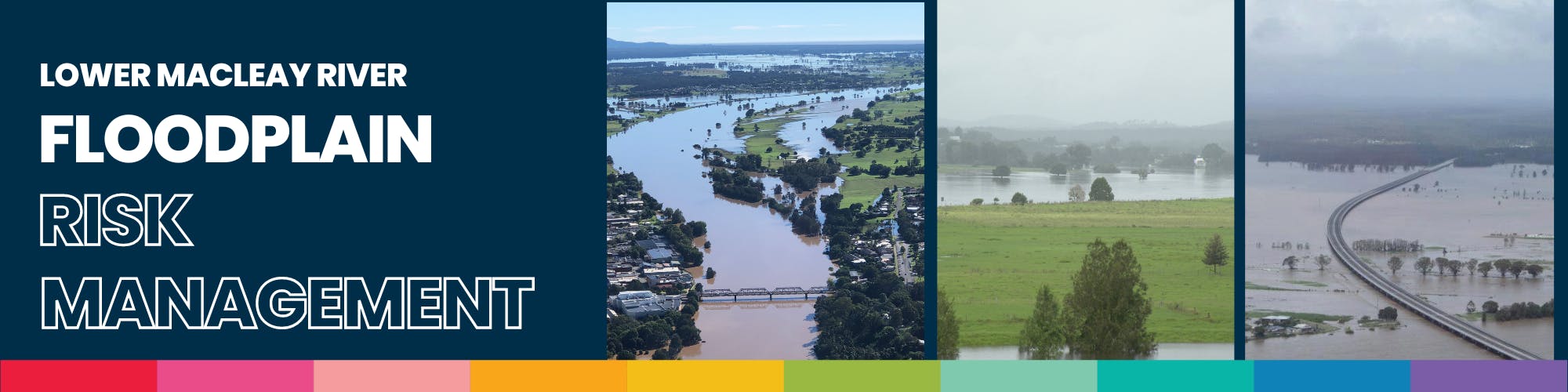
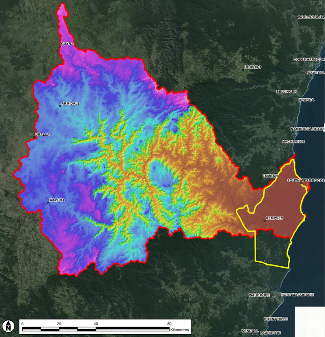
Kempsey township and the downstream communities of Frederickton, Gladstone and Smithtown have long been regarded as among Australia’s most high-risk flood impact locations. The Lower Macleay River floodplain occupies an approximately 500km² of coastal floodplain downstream of Kempsey, to the Macleay River’s main outlet at South West Rocks. The floodplain drains an upstream catchment area of 11,500km² and also has several secondary outlets to the ocean at Hat Head, Crescent Head, Ryans Cut and South West Rocks and a hydraulic link to the Maria River and Hastings River to the south, all owing to improved channel linkages constructed during historic flood mitigation schemes.
Project Summary
in 2019, Kempsey Shire Council prepared a flood study for the Lower Macleay to investigate mainstream flood behaviour in the broader Lower Macleay floodplain including villages and urban areas. That study included:
Review available catchment, topographic, flood and drainage infrastructure data; flood study reports, overland flow path studies and associated hydrologic and hydraulic models.
Undertake hydrologic analysis of upstream catchment inflows to define the river inflow characteristics for historic and design flood events and establish hydrologic models to estimate flood event inflows for the study area downstream of Kempsey.
Establish and calibrate a TUFLOW hydraulic model for the study area to determine flood hydraulic behaviour, with consideration of interactions with flooding in adjacent river catchments and the ocean. There is a particular emphasis on floodplain villages, flood mitigation infrastructure and ocean outlets.
Prepare flood mapping including peak flood extents & levels, depths and velocities for all modelled events.
Assess the sensitivity of flooding to modelling assumptions.
Assess the sensitivity of flooding to climate change, including sea level rise and increased rainfall.
Undertake community consultation to communicate the outcomes of this study.
Prepare a report on the above (see link to report in sidebar documents).
The next part of the Flood Management Program includes the implementation of a Flood Risk Management Study and Plan.
Lower Macleay River Floodplain Risk Management Plan
In 2019 Kempsey Shire Council (Council) prepared a flood study for the Lower Macleay under the Flood Management Program in accordance with the Floodplain Development Manual.
The next stage includes the creation of a Flood Risk Management Study and Plan which identifies priority risk reduction measures for further investigation and implementation under the Flood Risk Management Program.
The Lower Macleay Flood Risk Management Study and Plan key objectives are:
Develop a risk management study and plan to mitigate the impacts of flooding now and into the future.
Analyse and refine the scheme using the detailed modelling available, with the aim of reducing the flood impacts to the community in frequent flood events.
Understand where the evacuation constraints lie and whether emergency management capacity can be improved.
Update Flood Planning Levels.
Obtain a singular unified model for downstream of Kempsey CBD and the Lower Macleay floodplain, extending to the LGA boundary to the south.
Flood Risk Reference Group
The Flood Risk Management Reference Group forms part of the Flood Risk Management (FRM) governance as specified in the FRM Manual 2023. Membership of the FRM reference group is recommended to include a balanced representation of stakeholders such as agencies, groups and/or individuals affecting, affected by or coordinating FRM including but may not be limited to:
The Mayor as the Chairperson,
A Councillor Delegate to the Flood Risk Management Reference Group by Open Voting,
Council staff involved in FRM including engineering, EM, land-use planning and environmental disciplines.
local community representatives – this may include local flood affected landholders.(Residential and business),
relevant industry bodies (for example, the chamber of commerce), environmental groups and representatives of First Nations people.
other key stakeholders, such as owners or managers of infrastructure or land that may influence flood behaviour.
government representatives from the lead agencies for FRM and flood combat and
EM, or officers from other relevant agencies
specialist consultants may inform the reference group and attend meetings if invited.
The reference group will be principally set up for the Lower Macleay Flood Risk Management Plan with ongoing consideration to projects/significant floodplain matters central around the Flood Risk Management Manual.
We understand many of our community have been impacted by flood events and would like to share their experience and knowledge to ensure our community remains safe the next time a flood event occurs.
If you would like to apply to be a member of the Flood Risk Committee, please read the Terms and Conditions and submit your Expression of Interest below. The EOI will be reviewed by the Project Team and successful applicants notified. Applications close on 8 December 2023.
Protecting our future against flood events
How should we manage risks for future flood events and how can we better plan and prepare for future flood events?
Kempsey township and the downstream communities of Frederickton, Gladstone and Smithtown have long been regarded as among Australia’s most high-risk flood impact locations. The Lower Macleay River floodplain occupies an approximately 500km² of coastal floodplain downstream of Kempsey, to the Macleay River’s main outlet at South West Rocks. The floodplain drains an upstream catchment area of 11,500km² and also has several secondary outlets to the ocean at Hat Head, Crescent Head, Ryans Cut and South West Rocks and a hydraulic link to the Maria River and Hastings River to the south, all owing to improved channel linkages constructed during historic flood mitigation schemes.
Project Summary
in 2019, Kempsey Shire Council prepared a flood study for the Lower Macleay to investigate mainstream flood behaviour in the broader Lower Macleay floodplain including villages and urban areas. That study included:
Review available catchment, topographic, flood and drainage infrastructure data; flood study reports, overland flow path studies and associated hydrologic and hydraulic models.
Undertake hydrologic analysis of upstream catchment inflows to define the river inflow characteristics for historic and design flood events and establish hydrologic models to estimate flood event inflows for the study area downstream of Kempsey.
Establish and calibrate a TUFLOW hydraulic model for the study area to determine flood hydraulic behaviour, with consideration of interactions with flooding in adjacent river catchments and the ocean. There is a particular emphasis on floodplain villages, flood mitigation infrastructure and ocean outlets.
Prepare flood mapping including peak flood extents & levels, depths and velocities for all modelled events.
Assess the sensitivity of flooding to modelling assumptions.
Assess the sensitivity of flooding to climate change, including sea level rise and increased rainfall.
Undertake community consultation to communicate the outcomes of this study.
Prepare a report on the above (see link to report in sidebar documents).
The next part of the Flood Management Program includes the implementation of a Flood Risk Management Study and Plan.
Lower Macleay River Floodplain Risk Management Plan
In 2019 Kempsey Shire Council (Council) prepared a flood study for the Lower Macleay under the Flood Management Program in accordance with the Floodplain Development Manual.
The next stage includes the creation of a Flood Risk Management Study and Plan which identifies priority risk reduction measures for further investigation and implementation under the Flood Risk Management Program.
The Lower Macleay Flood Risk Management Study and Plan key objectives are:
Develop a risk management study and plan to mitigate the impacts of flooding now and into the future.
Analyse and refine the scheme using the detailed modelling available, with the aim of reducing the flood impacts to the community in frequent flood events.
Understand where the evacuation constraints lie and whether emergency management capacity can be improved.
Update Flood Planning Levels.
Obtain a singular unified model for downstream of Kempsey CBD and the Lower Macleay floodplain, extending to the LGA boundary to the south.
Flood Risk Reference Group
The Flood Risk Management Reference Group forms part of the Flood Risk Management (FRM) governance as specified in the FRM Manual 2023. Membership of the FRM reference group is recommended to include a balanced representation of stakeholders such as agencies, groups and/or individuals affecting, affected by or coordinating FRM including but may not be limited to:
The Mayor as the Chairperson,
A Councillor Delegate to the Flood Risk Management Reference Group by Open Voting,
Council staff involved in FRM including engineering, EM, land-use planning and environmental disciplines.
local community representatives – this may include local flood affected landholders.(Residential and business),
relevant industry bodies (for example, the chamber of commerce), environmental groups and representatives of First Nations people.
other key stakeholders, such as owners or managers of infrastructure or land that may influence flood behaviour.
government representatives from the lead agencies for FRM and flood combat and
EM, or officers from other relevant agencies
specialist consultants may inform the reference group and attend meetings if invited.
The reference group will be principally set up for the Lower Macleay Flood Risk Management Plan with ongoing consideration to projects/significant floodplain matters central around the Flood Risk Management Manual.
We understand many of our community have been impacted by flood events and would like to share their experience and knowledge to ensure our community remains safe the next time a flood event occurs.
If you would like to apply to be a member of the Flood Risk Committee, please read the Terms and Conditions and submit your Expression of Interest below. The EOI will be reviewed by the Project Team and successful applicants notified. Applications close on 8 December 2023.
Council is developing a Flood Risk Managment Reference Group.
The aim of this initiative is to give the community and Council the opportunity to discuss flood risk management for the Lower Macleay directly with experts, provide valuable local knowledge to help inform decision making, identify risks and concerns, as well as provide a forum for shared learning and improvement.
We are asking interested community members to apply for a place on the reference group via this Expression of Interest process.
We are looking for a broad variety of representatives, so if you are interested in flood risk management and think you have something to offer, please apply.
Share Flood Risk Management Reference Group Expression of Interest on FacebookShare Flood Risk Management Reference Group Expression of Interest on X (formerly Twitter)Share Flood Risk Management Reference Group Expression of Interest on LinkedinEmail Flood Risk Management Reference Group Expression of Interest link